
NaMaRes 2.0 –
Digital urban resource management in districts

The sustainability and resilience of existing urban districts are moving into the focus of political and social attention. The pressure to use existing resources and potentials calls for an integrated, resource-efficient development of districts, urban transformation, and concrete solutions. The namares projects aim to digitally support the integrated planning and transformation process at the district level. The software developed in the first phase will be tested and developed in several test areas and municipal planning processes.
Sustainable cities and municipalities
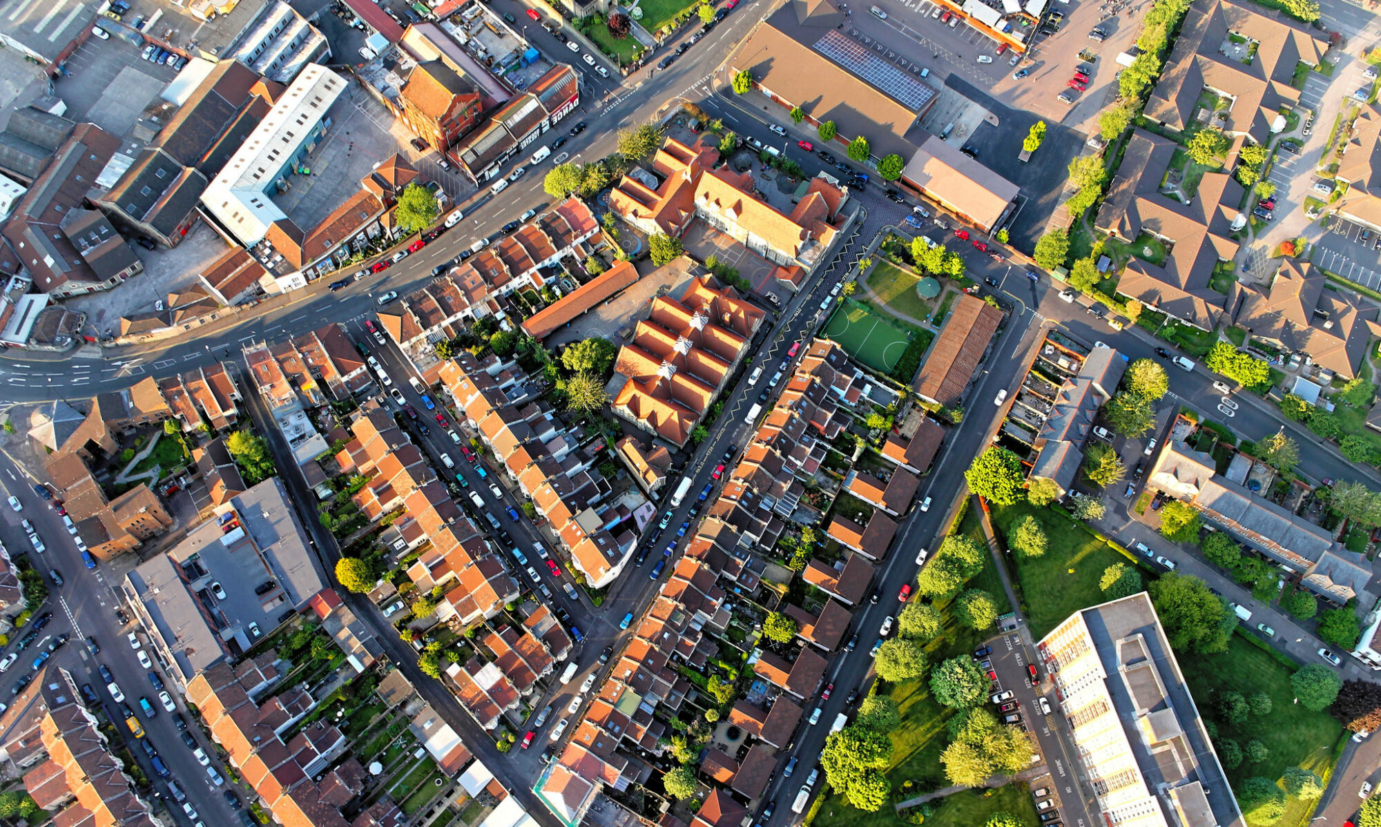
Cities are in a constant state of change. This process is driven by society’s desire for modern, sustainable, and liveable places to live and work. It is also driven by the megatrends of climate change, resource scarcity, demographic change, and globalisation.
SDG 11 aims to make cities and communities more inclusive, safe, resilient, and sustainable. The involvement of civil society and many other stakeholders is crucial to the success of this transformation. The contribution of cities to sustainable development is, therefore, a complex management task. The challenges are particularly significant in existing and historically grown urban areas and districts.
This project aims to develop and digitally support (through software) an integrated planning and transformation process at the district level to transform existing districts into sustainable, resource-efficient urban districts.
Digital support for urban development
In the first phase of funding, the basics and a prototype software application were developed for assessing the current state of urban districts and for conceptualising sustainability measures and assessing their potential. Tools were developed for district-level information processing (e.g., recording and mapping of ecosystem services) and decision support (e.g., a software application for district assessments), indicators for resource efficiency at the district level and guidelines for operationalising development strategies. The project results contribute greatly to improving the information base on existing districts regarding resource availability and use. These results make an important contribution to the operationalisation and local implementation of SDG 11.
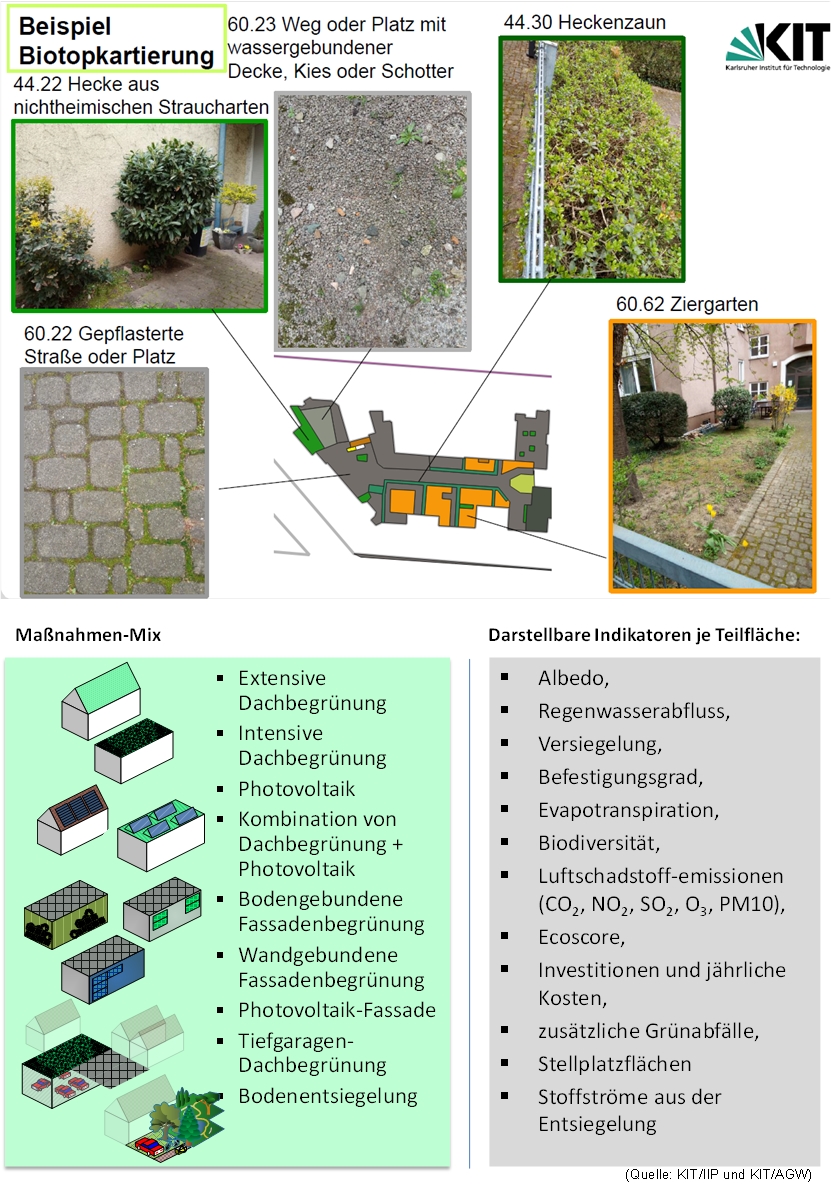
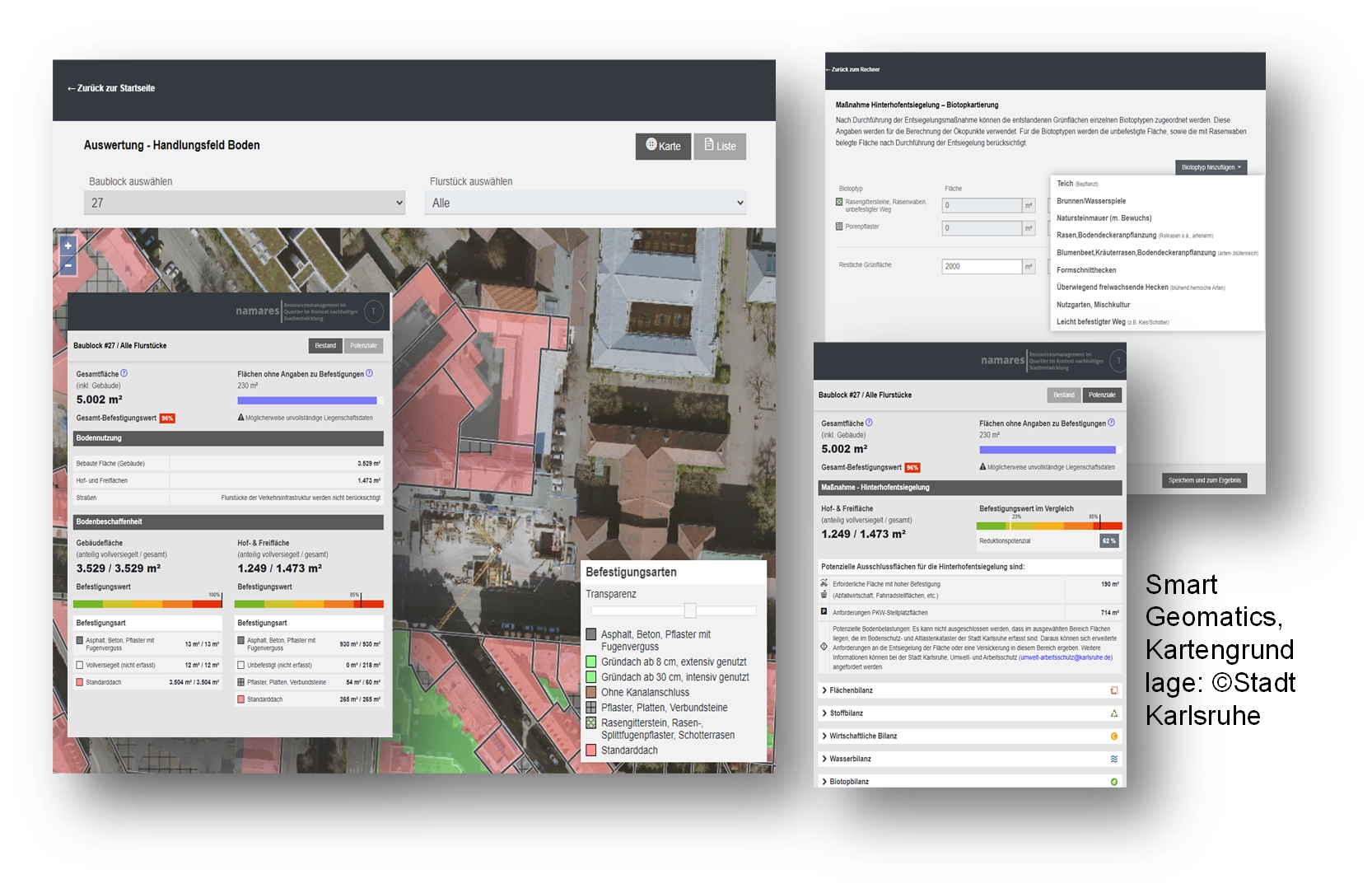
The tools and software application have a very granular work structure, allowing conclusions to be drawn about individual land plots and building surfaces. The tools use existing urban data on buildings and land use as a basis for operation. Data quality on public spaces in a district is good, but data on private green spaces is lacking. These have been collected and evaluated for a comprehensive description of ecosystem services.
A software application and a web tool for digital data processing were developed. These tools map and evaluate nine different sustainability measures. The developed model individually assesses these measures with 12 main indicators for each plot and sub-area. For each measure, a specific technically feasible potential is simulated for implementation in the identified areas, and the effects are determined and economically evaluated (in euros).
The results can be retrieved for each sub-area, plot, building block, or district. This makes it possible to identify potential improvements (‘hotspots’) with particularly high cost-benefit ratios in the existing context and estimate the environmental impact and the initial and ongoing costs of possible measures.
From proof-of-concept to practical use
In the follow-up phase, namares 2.0, the developed tools will be extensively tested in practice and further developed according to user needs. The application will be tested in several municipalities (Cologne, Bruchsal and Bretten) to demonstrate how it can support formal urban planning and development processes and to ensure its transferability. Plausibility analyses and validations will be conducted, and workshops with municipalities and urban planners will be held to develop additional functionalities and measures. The implementation and institutionalisation phase aims to permanently use the software application and the guide in the participating municipalities for the continuous and digital support of urban resource management. To achieve this goal, the software prototype’s current Technology Readiness Level (TRL) will be increased from 3-4 to 6-7. For dissemination purposes, introductory courses will be offered to other interested municipalities.
Project title
NaMaRes 2.0 –
Digital urban resource management in districts
Internet
NaMaRes 2.0
Duration
01.07.2022–30.06.2024
Funding code
033W111AN
Funding
669.733 €
Contact
PD Dr. Rebekka Volk
Karlsruher Institut für Technologie (KIT), Institut für Industriebetriebslehre und Industrielle Produktion (IIP)
0721 608-44699
rebekka.volk@kit.edu
Project partners
Karlsruher Institut für Technologie (KIT)
Stadt Köln
Smart Geomatics GmbH
Umwelt- und Energieagentur Landkreis Karlsruhe
Universität Potsdam
Version of
Mai 2023
Information on the first funding phase (2019 – 2022) can be found here
Results
Results of the second funding phase

Project sheet NaMaRes 2.0
Results of the first funding phase
Results of 2019 – 2022 –
Contribution to the publication of the results of the first funding phase Software und Planungsgrundlagen für urbanes Ressourcenmanagement im Quartier
Results of 2021 – Contribution to the RES:Z-Newsletter 3: Werkzeugentwicklung zum nachhaltigen Ressourcenmanagement
Results of 2020 – Contribution to the RES:Z-Newsletter 2: Nachhaltiges Ressourcenmanagement
Results of 2019 – Contribution to the RES:Z-Newsletter 1: Strategien und Indikatoren
Publications
Krehl, A., Naber, E., Volk, R., Schultmann, F., & Norra, S. (2023). Erweiterung von Baumkatastern und Baumkartierungen zur Bestimmung von Ökosystemleistungen im Stadtgebiet (Version 1). Dresdner Flächennutzungssymposium 2023 (DFNS), Dresden. Zenodo. https://doi.org/10.5281/zenodo.8089410
Krehl, A., Naber, E., Volk, R., Schultmann, F., & Norra, S. (2023). Bestimmung von Ökosystemleistungen am Beispiel der Beschattungsleistung in Stadtgebieten durch eine Erweiterung des bestehenden Baumdatenbestands. In Flächennutzungsmonitoring XV (1.0). Dresdner Flächennutzungssymposium (DFNS 2023), Dresden, Deutschland. Zenodo. https://doi.org/10.5281/zenodo.10623494
Naber, E., Volk, R., Krehl, A., Norra, S., & Schultmann, F. (2023, Juni 13). Urbane Oberflächenmodelle und -inventare zur Operationalisierung der Planung von Klimaanpassungsmaßnahmen. DFNS 2023 – Dresdner Flächennuntzungssymposium (DFNS 2023), Dresden, Deutschland. Zenodo. https://doi.org/10.5281/zenodo.8120886
Naber, E., Volk, R., Krehl, A., Norra, S., & Schultmann, F. (2023). Urbane Oberflächenmodelle und -inventare zur Operationalisierung der Planung von Klimaanpassungsmaßnahmen. In Flächennutzungsmonitoring XV (1.0). Dresdner Flächennutzungssymposium (DFNS 2023), Dresden, Deutschland. Zenodo. https://doi.org/10.5281/zenodo.10686410
Volk, R.; Lützkendorf, T.; Schambelon, S.; Naber, E.; Mörmann, K.; Böhnke, D.; Norra, S.; Schuhmann, R.; Ehbrecht, A.; Balouktsi, M.; Schultmann, F. (2020): Stakeholder-specific assessment of environmental, economic and social effects of resource-efficiency measures in urban districts – first results, 2020. IOP conference series / Earth and environmental science, 588, Art.-Nr.: 052036. doi:10.1088/1755-1315/588/5/052036 (Konferenzbeitrag)
Böhnke D, Jerutka K. (2020): Stadtplätze: Zur Bewertung der Aufenthaltsqualität urbaner Räume, 2020. Stadt und Raum (6), 330 – 335
Boehnke, D., Krehl, A., Mörmann, K., Volk, R., Lützkendorf, T., Naber, E., Becker, R., and Norra, S. (2022). Mapping Urban Green and Its Ecosystem Services at Microsca-le—A Methodological Approach for Climate Adaptation and Biodiversity. Sustainability 14, 9029. https://doi.org/10.3390/su14159029
Böhnke, D., Volk, R., Lützkendorf, T., Naber, E., Krehl, A., Becker, R., and Norra, S. (2021). Grünbestände in privaten Innenhöfen und deren Ökosystemleistungen im Stadtquartier: Erkenntnisse einer quartiersweiten Erhebung in Karlsruhe. In Flächennutzungsmonitoring XIII: Flächenpolitik – Konzepte – Analysen – Tools. 149–157. https://doi.org/10.26084/13DFNS-P014
Böhnke, D. und Norra, S. (2021): Stadtquartiere im Klimawandel. Kommunales Nieder-schlagsmanagement in Bestand und Neubau. Erkenntnisse praxisnaher Forschung, Transforming Cities, Jg. 6 Nr. 3 2021, S.34-39, ISSN: 2366-7281
Naber, Elias; Volk, Rebekka; Mörmann, Kai; Boehnke, Denise; Lützkendorf, Thomas; Schultmann, Frank (2022): Namares—A Surface Inventory and Intervention Assessment Model for Urban Resource Management. In: Sustainability 14 (14), S. 8485. DOI: 10.3390/su14148485.
Volk, Rebekka; Rambhia, Mihir; Naber, Elias; Schultmann, Frank (2022): Urban Resource Assessment, Management, and Planning Tools for Land, Ecosystems, Urban Climate, Water, and Materials—A Review. In: Sustainability 14 (12), S. 7203. DOI: 10.3390/su14127203.
Schebek, Liselotte; Lützkendorf, Thomas (2022): Assessing Resource Efficiency of City Neighbourhoods. A Methodological Framework for Structuring and Practical Application of Indicators in Urban Planning. In: Sustainability 14 (13), S. 7951. DOI: 10.3390/su14137951.
Norra, S. (2022): The Astysphere – a concept to overcome the polarity between cities and nature and to develop sustainable urban raw material fluxes. In: IOP Conf. Ser.: Earth Environ. Sci. 1078 (1), S. 12063. DOI: 10.1088/1755-1315/1078/1/012063.
Naber, E.; Volk, R.; Krehl, A.; Norra, S.; Schultmann, F.: Urbane Oberflächenmodelle und -inventare zur Operationalisierung der Planung von Klimaanpassungsmaßnahmen
2023, Juni 13. Dresdner Flächennutzungssymposium (DFNS 2023), Dresden, Deutschland, 13.–14. Juni 2023. doi:10.5281/zenodo.8120886
Böhnke, D.; Volk, R.; Lützkendorf, T.; Naber, E.; Krehl, A.; Becker, R.; Norra, S.
2021: Grünbestände in privaten Innenhöfen und deren Ökosystemleistungen im Stadtquartier: Erkenntnisse einer quartiersweiten Erhebung in Karlsruhe. Flächennutzungsmonitoring XIII. Hrsg.: G. Meinel, 149–157, Rhombos-Verlag. doi:10.26084/13dfns-p014
Volk, R.; Naber, E.; Lützkendorf, T.; Böhnke, D.; Mörmann, K.; Schultmann, F.; Norra, S.
2021. Identifikation und Bewertung von Entsiegelungspotenzialen als Beitrag zur nachhaltigen Quartiersentwicklung: Zwischenergebnisse aus NaMaRes. Flächennutzungsmonitoring XIII. Hrsg.: G. Meinel, 209–219, Rhombos-Verlag. doi:10.26084/13dfns-p019
Volk, R.; Lützkendorf, T.; Schambelon, S.; Naber, E.; Mörmann, K.; Böhnke, D.; Norra, S.; Schuhmann, R.; Ehbrecht, A.; Balouktsi, M.; Schultmann, F.
2020. Stakeholder-specific assessment of environmental, economic and social effects of resource-efficiency measures in urban districts – first results. IOP conference series / Earth and environmental science, 588, Art.-Nr.: 052036. doi:10.1088/1755-1315/588/5/052036